Education
‘8th continent’ of the earth, Zealandia, is more precisely mapped by international experts
Published
8 months agoon
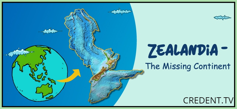
A more accurate map of Zealandia, the submerged eighth continent, has been released by a global team of geologists and seismologists
A committed group of geologists and seismologists from around the world have set out on a mission to map the depths of Zealandia, a relatively unexplored region buried beneath the Pacific Ocean. A new, extremely accurate map that highlights the fascinating geological aspects of the continent is the product of their work.
Where on Earth is Zealandia located?
A astonishing 94% of Zealandia, also referred to as the eighth continent, is buried beneath the ocean’s surface, leaving it shrouded in marine mystery. Island nations like New Zealand and its neighbouring isles are included in the remaining 6% that can be seen above the waters.
Zealandia’s geological history extends back around 83 million years, when volcanic forces played a critical role in the split of the supercontinent Gondwana, resulting in the continents we know today.
Disclosing the Cartographic Wonder
It took a lot of effort to produce the detailed map of Zealandia. The research team set out on a thorough voyage, employing a variety of approaches to shed light on this underwater world. What they did was as follows:
1. Oceanic Rock and Sediment Samples
The scientists carefully investigated rock samples and silt samples gathered from the ocean floor in order to improve the existing maps. These priceless resources were obtained through local drilling operations and coastal explorations.
Read also:-CELEBRATING TEACHERS ON THE TEACHER’S DAY
2. Analysis of Seismic Data
The route of the inquiry went beyond rock samples. In order to better understand the geology of the Zealandia region, the researchers examined seismic data collected there.
3. Continent-Wide Mapping
The scientists began the enormous task of charting Zealandia in unprecedented detail after acquiring these vital resources. A massive 5 million square kilometres make up this submerged continent.
Geological Secrets Unlocked
Intriguing geological patterns in Western Antarctica were discovered through the analysis of the materials, which may indicate the presence of a potential subduction zone close to Campbell Plateau on New Zealand’s western coast. Even with this information, predictions of a strike-slip along the Campbell Fault were not refuted by magnetic anomalies in the area.
The researchers hypothesised that the stretching of Gondwana during its fragmentation was the source of the Campbell Magnetic Anomaly System. This stretching eventually resulted in a massive rupture, which produced the ocean floor that presently makes up the lower portions of Zealandia.
You may like
-


On the Citizenship Amendment Act (CAA), PM Narendra Modi challenges Congress and the SP
-


Shortly After Slovak PM’s Assassination, As Crowd Held Gunman
-


Vladimir Putin, the leader of Russia, makes a state visit to China as a symbol of the alliances’ solidarity
-

NASA: Bright, tiny, plant-like creatures discovered in the Celtic Sea
-

Earth’s North Pole is moving more quickly
-


Kiara Advani will make her Cannes Film Festival debut in 2024